

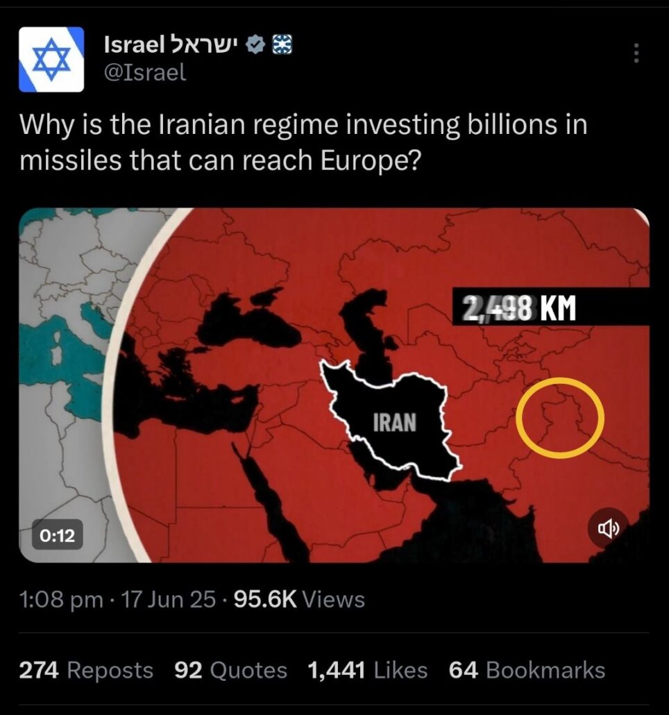
On June 17, the Israeli military once again came under fire after uploading a map on X (formerly Twitter) that incorrectly showed Jammu and Kashmir as part of Pakistan.
The post, intended to depict Iranian missile ranges, mirrored a similar error made just days earlier. The mistake was swiftly highlighted by fact-checker Muhammad Zubair of Alt News, following which the Israeli Defence Forces (IDF) deleted the post without issuing a fresh apology.
Again? @Israel @IsraelinIndia? pic.twitter.com/yzVmxD3NT0
— Mohammed Zubair (@zoo_bear) June 17, 2025
The incident marks the second time in four days that the IDF has posted an inaccurate map of India, sparking criticism across Indian social media. Many users tagged Israeli officials and demanded accountability, calling the repeated error disrespectful to India’s territorial integrity.
On June 14, the IDF had issued a formal apology for a similar error, stating: “This map fails to precisely depict borders. We apologize for any offense caused by this image.” At the time, the military clarified that the map was only an illustration meant to show regional missile threats.
India maintains that Jammu & Kashmir and Ladakh are integral parts of the country. Prime Minister Narendra Modi reiterated this stance following the Pahalgam terror attack and the launch of Operation Sindoor in May. The repeated misrepresentation has raised concerns in diplomatic circles, even as the two nations maintain close strategic, defence, and trade ties.
This episode also unfolds amid heightened tensions between Israel and Iran. In recent weeks, Israel has carried out major military strikes targeting Iran’s alleged nuclear infrastructure, prompting retaliatory missile attacks from Tehran. As both countries continue to exchange threats, the region remains on edge.
Despite the IDF’s removal of the second erroneous map, no fresh statement had been issued at the time of this report.

- News Deskhttps://thekashmiriyat.co.uk/author/kashmiriyat/

- News Deskhttps://thekashmiriyat.co.uk/author/kashmiriyat/

- News Deskhttps://thekashmiriyat.co.uk/author/kashmiriyat/
- News Deskhttps://thekashmiriyat.co.uk/author/kashmiriyat/

